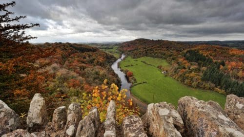
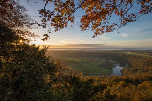
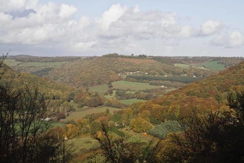
How about the Eagle’s Nest? Not a real one, but a double-decker viewing platform, perched precariously on cliffs with the most amazing eagle’s eye views over the Wye. Or the Devil’s Pulpit from where (legend has it) the devil preached to the monks down below at Tintern Abbey, taunting them to come and join him? Or the Wye Valley’s most iconic view from Symond’s Yat Rock where the Wye meanders in a huge loop, hundreds of feet below.
This iconic viewpoint delights visitors of all ages with its bird’s eye panorama of the Wye. The commanding view and cliff top location was also valued by much earlier people. providing an excellent vantage point for Iron Age inhabitants who built a fort here 2,500 years ago. Eighteenth century Wye Tourists loved this famously picturesque view. They left their tour boats and walked up to the viewpoint here, whilst the crew rowed the boats around the four mile loop to New Weir to meet the tourists. You can follow in their footsteps and take the steep path down to the riverside at Symonds Yat East, from where a hand ferry can still be hailed to take you to New Weir on the opposite bank. Today Yat Rock attracts many ornithologists as its one of the best places in the country to catch sight of peregrine falcons who nest on nearby Coldwell Rocks. You might also see goshawks, sparrowhawks and even an osprey as they often stop here in the spring and autumn migration.
A view of the River Wye from Symonds Yat on the borders of Gloucestershire and Herefordshire, England.
Access to Yat Rock is via a footpath from the main Forestry Commission car park at Symonds Yat. Symonds Yat is one of the most accessible viewpoints in the Wye Valley for pushchairs and wheelchairs. There is a log cabin café and toilets.
Walks here: Follow in the footsteps of the Wye Tourists on The Head for the Hillforts walk which leads down to the Wye, crossing it via the Biblins footbridge, visiting Little Doward Hillfort, King Arthur’s Cave and New Weir Forge and returning on the hand ferry at Symonds Yat West.
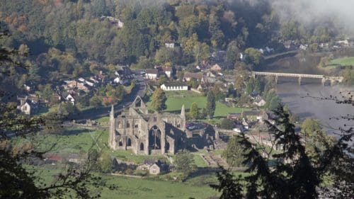
This narrow pillar of limestone on the edge of the Wye gorge has magnificent views over Tintern Abbey and was a popular site with the Wye Tourists. Surrounded by ancient and weirdly-shaped yew trees, this is a mysterious spot. Legend has it that the ‘pulpit’ was used by the devil to cajole the monks toiling below and persuade them to join him!
Access: This view is only accessible on foot. A fairly steep walk from Tintern crosses the old wireworks bridge and heads up to Offa’s Dyke Path National Trail. You can spot stretches of ancient earthwork along the route, adding to the sense of history on this walk.
Easier access is from the sign-posted Forest Enterprise car park on the B4228, near Tidenham Chase, from where a more level route leads you to the Offa’s Dyke Path National Trail which passes Devil’s Pulpit.
Pass some of the best-preserved sections of the 8th century Offa’s Dyke on the way to the Devil’s Pulpit
Walks here: Devil’s Pulpit is on the Offa’s Dyke National Trail path. Two circular walks including a stretch along Offa’s Dyke lead to the Devil’s Pulpit.
This is a lovely place to watch the sun set across the Lancaut peninsular with views towards the Piercefield Estate and Wyndcliffe. These stunning limestone cliffs, where peregrine falcons now nest, were extensively quarried in the past. Their name comes from Sir John Wintour who is alleged to have galloped over these precipitous cliffs in 1642 in a bid to escape from Parliamentarians during the Civil War.
Access: There is no roadside parking but you can park at nearby Lancaut and follow Offa’s Dyke National Trail path back to the viewpoint.
Walks here: You can follow the 6 mile Discover the Lancaut Peninsular from Chepstow which passes Wintour’s Leap on the way.
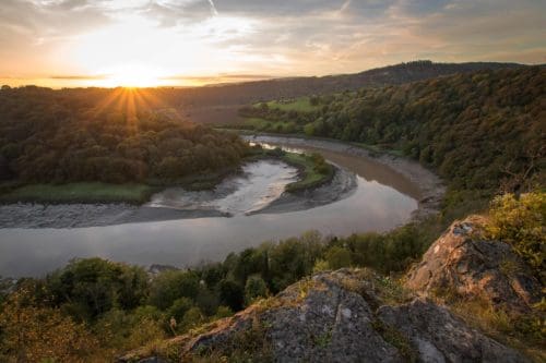
High tide and sunset make for the best reflections from Wyntour’s Leap viewpoint
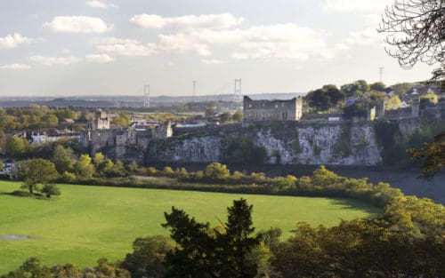
Piercefield Park was laid out in the 18th Century by Valentine Morris who wanted to create a ‘picturesque’ landscape walk, taking visitors to the most picturesque viewpoints overlooking the Wye. Piercefield became an unmissable attraction on the Wye Tour and many of Morris’s views remain. The Alcove was the first of the viewpoints constructed around 1750, from where Arthur Young, visiting in 1768 thought, ‘the town and castle of Chepstow appear… in a manner too beautiful to express’. Other viewpoints include the Lover’s Leap and the Giant’s Cave and the trail culminates at Eagle’s Nest on the Wyndcliff, probably the most spectacular!
The history of the Piercefield Estate is intertwined with the slave trade
Access Park in Chepstow Leisure Centre car park, from where the Wye Valley Walk leads to successive views along the Piercefield Walk.
Walks here: The circular Picturesque Piercefield Walk explores these viewpoints which are also linked by the linear Wye Valley Walk.
This double-decker viewing platform perched on the edge of the cliff is perhaps the most spectacular viewpoint in the Wye Valley. The ‘Eagle’s Nest’ looks out over the sweeping curve of the Wye around the Lancaut Peninsula, whilst in the distance the river flows into the Severn. The Wyndcliff was the start (or finish) of Valentine Morris’s Piercefield Walk, and was the highest point with the grandest view. Coleridge, one of the Romantic poets, described the Wyndcliff panorama as ‘the whole world imaged in its vast circumference’ and on a clear day you can see seven counties. Lookout for some Victorian graffiti!
Feast your eyes on the panorama from the Eagle’s Nest – definitely worth the climb!
Access: There are two routes. The first, via the strenuous ‘365 Steps’ (one for each day of the year which were cut into the rock for the Duke of Beaufort in the 1820s), starts at the Lower Wyndcliff car park adjacent to the A466, just north of St Arvans.
A gentler climb to the Eagle’s Nest starts from the Upper Wyndcliff car park, which is reached via a lane off the A466, ½ mile north of St Arvans.
Easier Access: There is a very short path on the right of the Upper Wyndcliff car park which leads to a bench with views looking out over the river.
There is easy access to a similar (but lower view) from the Lower Wyncliff car park alongside the A466, between St Arvans and Tintern. With picnic tables, this is a pleasant place for a picnic.
Walks here: The Picturesque Piercefield Walk visits the Eagle’s Nest and Lower Wyndcliff, as does the Wye Valley Walk.
The view from the Round House, standing on top of the Kymin hill overlooking Monmouth, is one of the most far-reaching views in our Top Ten list, extending over much of rural Monmouthshire taking in the Black Mountains, Hay Bluff and the Brecon Beacons.
During the 18th century it became fashionable to build summerhouses at sites with spectacular viewpoints and the Monmouth Picnic club chose The Kymin to build their small two-storey circular banqueting house in 1794. Guests who came here received instructions on how to observe the views in the correct Picturesque manner. A Naval Temple was built here in 1801 and, when Nelson visited Monmouth the following year, guns boomed out from the Temple to greet him as his tour boat from Ross came into view on the river below. Nelson enjoyed a breakfast in ‘The Round House’ and described the Kymin as one of the most beautiful places he had ever seen. Find out more here.
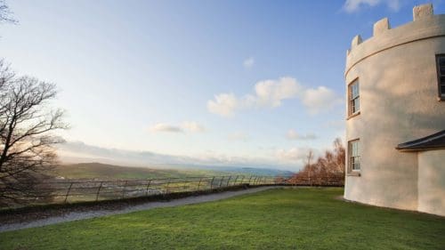
Access: Signposted off the A4136 between Monmouth and Coleford access is via a narrow, windy and in places steep single track road to the National Trust carpark. There is a very short walk from the carpark to the Round House and viewpoint. The grounds are open daily from dawn to dusk and the Round House is open from the end of March until end of October on Saturdays, Sundays and Mondays.
Capler Camp is an iron-age hill fort and tradition has it as the burial place of a British chieftain. Excavations have uncovered a 2nd century Roman coin and Neolithic and Bronze Age artefacts. It was a popular with Wye Tourists during the 18th century, with distant views towards Ross-on-Wye. Beside the road, just below the hill fort is Capler Viewpoint, with seating and views out over the river, making a pleasant place for a picnic. On the riverside below Capler Hill is the remains of a small quarry where stone was extracted and taken by barge upstream to Hereford to build the Cathedral.
Walks from here: A 2-mile circular route will take you from the river to the hillfort and viewpoint.
Access: There is a small carpark and picnic place on the B4224 south of Fownhope.
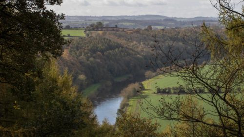
Overlooking the Wye at Capler picnic site
The views from Lancaut are unusual in that they look up to the surrounding limestone cliffs towering above the lost medieval village of Lancaut and the ruins of St James’ church. This is a special place, where the river makes a massive loop around a peninsular of land which seems lost in time.
Walks from here: There is a short circular walk from the carpark at Tidenham through the Lancaut Nature Reserve or you can follow the 6 mile Discover the Lancaut Peninsular from Chepstow, on a path running along the edge of the cliffs where peregrines nest and down through ancient woodland to the romantic ruins of Lancaut Church.
Access: Closest parking is at the Lancaut Lane carpark beside the falcon sculpture, ½ mile north of Woodcroft off the B4228.
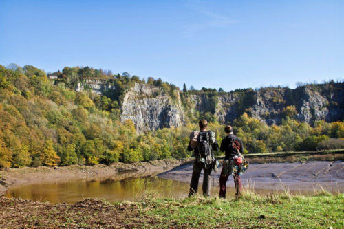
At Lancaut the voices of climbers mingle with the calls of peregrines, echoing around the cliffs.
It is thought that the views from Whitestone and Cleddon inspired Wordsworth to write ‘Lines composed a few miles above Tintern Abbey’. He wrote that, ‘no poem of mine was composed under circumstances more pleasant for me to remember than this’. You can follow in his footsteps, exploring the unexpected views in the woodland here, on the Welsh side of the Wye. At Whitestone benches are conveniently placed at three viewpoints, each providing a more spectacular view over Llandogo and the river. Walking 1 ½ miles north further along the Wye Valley Walk will bring you to Cleddon Shoots. Today the ancient woodland limits views across the valley, but the views of this pretty waterfall can be spectacular in wet weather.
Looking towards England and Cadora Woods from Whitestone.
Walks here: Whitestone walk
The Wye Valley Walk skirts Whitestone and you can join it just after the third viewpoint, walking north for about 1 ½ miles to Cleddon Falls, where you can start The Wordsworth Walk a steep walk which passes the ‘shoots’ on the way down to Llandogo and returns via the intriguingly named Bread and Cheese Stones.
Continue along the Wye Valley Walk for another 1 ½ miles through Cuckoo Wood and you will reach Duchess’s Ride, from where there are lovely views looking down the Valley towards the old Severn Bridge and the River Severn.
Access Whitestone: Car park and picnic site off the Llandogo/Trellech Road. A path from the upper car park heads up hill passing three viewpoints, each providing a more spectacular view over Llandogo.
Easy Access for Buggies and Wheelchairs along the Whitestone walk.
Access Cleddon Falls: There is a small parking area at the top of the Falls, where you can join The Wordworth Walk. Alternatively you can park in Llandogo and start the Wordsworth Walk at Brown’s Village Stores.
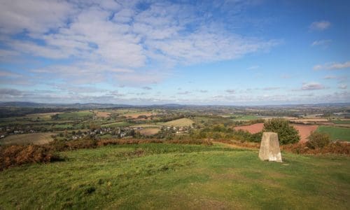
Alongside many viewpoints you may find trig points, the concrete pillars which the Ordnance Survey used to remap the UK in the 1930s. For ‘collectors’ of trig points a walk to the top of Coppett Hill will reward with both the view and another trig in the bag! The panorama here stretches from the Brecon Beacons and Clee Hill to the Malverns. In the 19th century The Folly and Ridge Path were constructed as viewing points, which you can enjoy today on one of the many permissive footpaths which cross Coppett Hill Common Local Nature Reserve.
Walks here: A book of walks on Coppett Hill is available from Jollys shop in Goodrich and Goodrich Castle shop.
Download A Short Walk on the Hill leaflet
Access: There is no parking on Coppett Hill and access is on foot only. Follow signs for Goodrich Castle with its car park and toilets and walk back through Goodrich following the signs to Welsh Bicknor.
On still sunny days, look out for the rare Pearl-bordered Fritillary butterfly found on Coppett Hill.